
News from the Niagara Peninsula Conservation Authority (NPCA) in Niagara, Ontario
Posted October 12th, 2026 on Niagara At Large
 The Niagara Peninsula Conservation Authority (NPCA) is inviting residents, property owners and stakeholders to review and provide feedback on final mapping for the Upper Welland River Tributaries in Haldimand, Hamilton, West Lincoln, and Wainfleet.
The commenting period runs from September 29 to October 27, 2026, and provides a final opportunity to validate the draft mapping with stakeholders and identify any additional concerns or information that may require revisions.
Community members can:
Review the mapping, provide comments or ask questions through the online Q&A: Get Involved NPCA
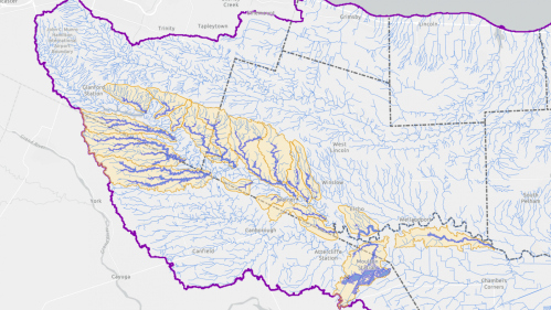
Floodplain map area courtesy of the Niagara Peninsula Conservation Authority
Send feedback directly to Brendan Buggeln, Manager of Natural Hazard Management and Resiliency: floodmapping@npca.ca
Explore the draft mapping using the Interactive Mapping tool available through the Get Involved portal.
The Upper Welland River Tributaries Floodplain Mapping Study was undertaken to better understand flood risks and how flooding may affect communities, properties and infrastructure within the study area – 19 tributaries to the Upper Welland River. It used updated technical information and modelling to identify areas that may be vulnerable to flooding, resulting in mapping that will help support future planning, emergency preparedness and flood risk management.
The study began in October 2025, followed by a public open house in November where community members had an opportunity to learn about the project and share their local knowledge. Updates and community engagement opportunities continued through spring 2026 alongside the technical work and development of the floodplain mapping.
The study has now reached its final commenting stage. If no further revisions are identified through the commenting period, the mapping will be brought forward to the NPCA Board of Directors for final approval on November 27, 2026.
For more information about the Upper Welland River Tributaries Floodplain Mapping Study, visit the NPCA Get Involved portal or contact floodplainmapping@npca.ca.
 About Niagara Peninsula Conservation Authority: As a community-based natural resource management agency, the Niagara Peninsula Conservation Authority envisions a healthy and vibrant natural environment with shared greenspace and clean water for all. NPCA’s work supports the conservation, enhancement, and sustainability of healthy watersheds with programs and services that focus on drinking water source protection, flood and hazard management, ecosystem restoration, community stewardship, education, and land management.
NPCA is the caretaker of 43 conservation areas within the Niagara Peninsula watershed held in public trust for recreation, heritage preservation, conservation, and education. These natural and shared greenspaces marry nature, culture, and adventure to create limitless opportunities for discovery.
NIAGARA AT LARGE Encourages You To Join The Conversation By Sharing Your Views On This Post In The Space Following The Bernie Sanders Quote Below and by sharing the Niagara At Large site at www.niagaraatlarge.com with all of your friends and associates.
“A Politician Thinks Of The Next Election. A Leader Thinks Of The Next Generation.” – Bernie Sanders –

