
Warning Covers this Sunday, November 15th at Noon Thru Mid-Day Monday, November 16th
An Urgent Notice from the Niagara Peninsula Conservation Authority, Conservation Authorities in the Grant River & Long Point Areas, and Environment Canada
Posted November 15th, 2020 on Niagara At Large
 For Sunday November 15, 2020, this notice is intended to update the public and local municipalities of the condition of the Lake Erie Shoreline as it relates to the Niagara Peninsula and the eastern portion of Haldimand County.
Niagara is currently under a Wind Warning as issued by Environment Canada, calling for very strong southwesterly winds gusting to 100+km/hr. These winds will significantly increase water levels and waves along the Lake Erie Shoreline.
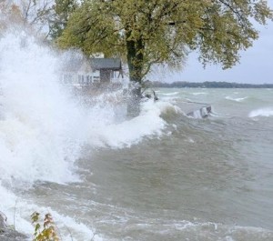
High winds push flooding waters up the shores of Lake Erie during a past storm.
The Ministry of Natural Resources and Forestry is currently predicting water levels to increase by 1.98m (6.5 feet) above current levels to an elevation of approximately 176.48m IGLD85. Significant wave heights of 2.0m (6.6 feet) are also forecast to occur all along the entire Lake Erie shoreline. Water levels will start to build this morning with peak water levels occurring around 7:00pm tonight.
Residents living along Lake Erie should pay very close attention to water levels and waves in their area and are urged stay away from the shoreline of Lake Erie during this event. Residents are also advised to close storm shutters and take other flood proofing precautions as necessary. Increased erosion and flooding due to storm surge and strong waves is likely.
Information on the Flood Status in the watershed and water levels on Lake Erie can be found on the NPCA’s website at: https://npca.ca/flood-status
https://npca.ca/stream-flow-monitoring
This notice is in effect until noon, Monday November 16th, 2020 and will be updated as required.
NIAGARA AT LARGE Encourages You To Join The Conversation By Sharing Your Views On This Post In The Space Following The Bernie Sanders Quote Below.
