
A Submission from the Canada/U.S. environmental coalition, Great Lakes United
Great Lakes United and the International Institute of Concern for Public Health (IICPH) released this May 6 the Great Lakes Nuclear Hot Spots Map, providing a detailed regional, binational view of nuclear facilities in the Great Lakes Region.
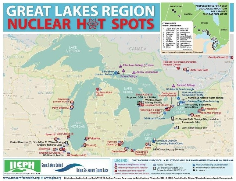
New Nuclear Site map for Great Lakes. Click on this map to blow it up to full screen to better view hotspots.
As the map shows, with the exception of Lake Superior, each of the Great Lakes has numerous nuclear sites related to nuclear power generation, most of which are located within one kilometre of the Lakes. This raises concerns about the cumulative impacts of radioactive releases over the years from so many sites. It also shows the numerous places where a serious nuclear accident could occur in the region.
This map marks the first comprehensive update of this information in 15 years and highlights the lack of information about radioactive releases from these facilities. In 1998, the International Joint Commission’s (IJC) Task Force on Inventory of Radionuclides released an assessment of nuclear facilities around the basin. At the time, the Task Force concluded that releases from nuclear facilities were substantial, but that the extent of knowledge about the releases and their impacts was “limited”. http://www.ijc.org/files/publications/C131.pdf
The map includes all aspects of nuclear power production in the Great Lakes region, including the 38 operating nuclear power plants, 12 closed plants, and four new plants proposed in Canada. It also includes the facilities that process uranium ore and manufacture the pellets, as well as tailings sites from uranium mining from mining, and facilities that store, and dispose of radioactive waste. Every site on the map is a radioactive waste site, whether operating or not.
The Great Lakes Nuclear Hot Spots Map provides a critical resource for communities concerned about the potential for radioactive waste releases into the Great Lakes and St. Lawrence River. Additionally, it shows the sites under consideration by the Canadian Government for storing Canada’s nuclear fuel waste. Most of the proposed sites lie within the Great Lakes basin. With the potential for new disposal sites within easy access of the Great Lakes, communities are concerned that nuclear waste could be brought in via ships, creating substantial risks of spills along Great Lakes-St. Lawrence River shipping lanes and during loading and unloading near shore.
The Citizens’ Clearinghouse on Waste Management contributed funding to this project.
For more information on Great Lakes United and its decades-long efforts as an advocate for Great Lakes waters and wildlife visit http://www.glu.org/ .
(Niagara At Large invites you to join in the conversation by sharing your views on the content of this post below. For reasons of transparency and promoting civil dialogue, NAL only posts comments from individuals who share their first and last name with their views.)

Doesn’t everyone like catching perch with legs and three eyes?
LikeLike